
Knowing how to measure slope angles is important for avalanche terrain identification. Here are a couple ways to measure slope angles.

Knowing how to measure slope angles is important for avalanche terrain identification. Here are a couple ways to measure slope angles.
Route finding in and around avalanche terrain is an important skill. Knowing how to measure runout angles is a useful skill to help you determine if you are in an avalanche path or out of the runout zone.

In rare cases of wet slab avalanches or slush avalanches, these rules of thumb for alpha angle may not apply. These avalanches might run further.
Downloadable apps for measuring runout angles include:
https://wbskiing.com/inclinometer.php
https://play.google.com/store/apps/details?id=com.glidelinesystems.dioptra&hl=en_US

The Gallatin National Forest Avalanche Center covers a lot of terrain around Island Park, West Yellowstone, Big Sky and Bozeman, Montana. You can find the website at mtavalanche.com
The following video highlights the information available on the website, as well as how one can use it before heading out in the backcountry.
Take the time to practice with your transceiver early season. The snow doesn’t have to be deep. Here’s a quick run down of what we start with early season.
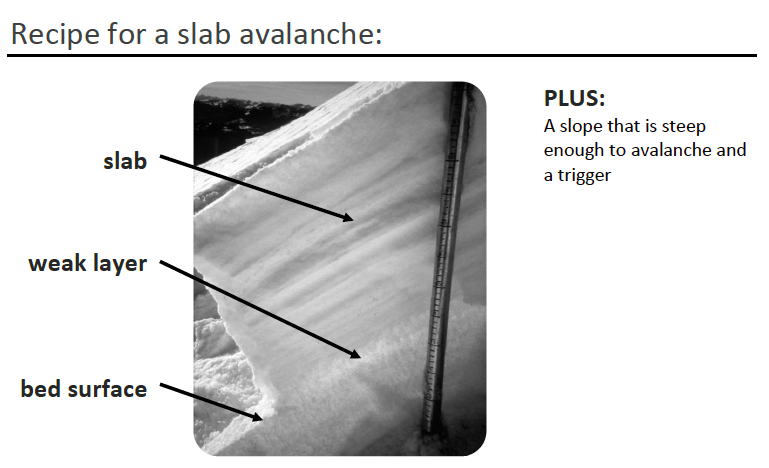
When thinking about snowpack, the primary question to ask is: Do we have a recipe for an avalanche?
The recipe for an avalanche consists of a SLAB, a WEAK LAYER, a BED SURFACE, and TERRAIN steep enough to slide.
Don Sharaf introduces the recipe for an avalanche and how snow metamorphism plays a part in this in the following video.
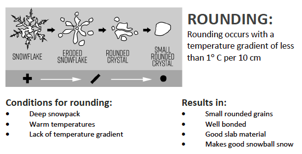
What forms a slab?
One process that forms slabs is rounding. Rounding is a strengthening process that happens at small temperature gradients.
Watch the following video to learn more about rounds, as well as other processes that form slabs.
What forms a weak layer?
One process that forms a weak layer is faceting. Faceting occurs when a large temperature gradient exists.

Let’s take a deeper dive into weak layer formation and what processes develop common weak layers.
The final component for the recipe for an avalanche is the bed surface? What processes form bed surfaces? How do you recognize them? Watch this final video to learn more.
Here is a copy of the checklist to use as we go through planning a tour.


Start by looking at this avalanche forecast:
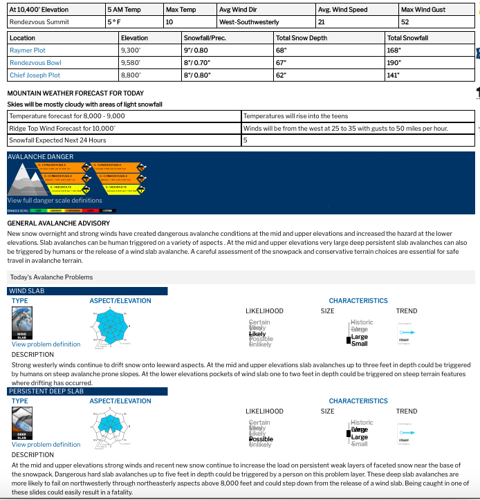
What jumps out at you? What elevations do you want to avoid? What aspects? What slope angles?
Watch this video to go through a tour plan with AAI instructor, Sarah Carpenter
The Bridger Teton Avalanche Forecast Center covers the mountains around Jackson and Alpine, WY. There are three forecast areas in this region – Teton Area, Togwotee Pass, and the Greys River Area.
The following video walks through the website in an effort to highlight the information that Sarah and others use on a daily basis.
Is this your forecast region? You can find it at jhavalanche.org.
The Utah Avalanche Center forecasts for the state of Utah, dividing it up into a variety of zones.
This video will walk you through the website, highlighting the information available, as well as where to find it.
Recognizing avalanche terrain is an essential skill. As you spend more time in the backcountry, this terrain recognition will help you to navigate a variety of conditions throughout the winter.
If there is ever a question on a backcountry day – a question about snowpack, a question about weather, strange group dynamics – terrain is the answer. We say this because you can control your exposure to avalanche hazard through terrain choice. There are days when you may choose to avoid avalanche terrain and days when you feel confident traveling in avalanche terrain.
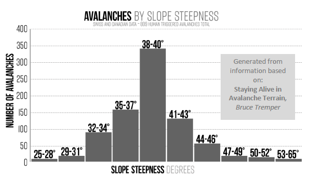
Most slab avalanches occur on terrain that is between 30°-45°. Measuring slope angle is one thing that you can do as a backcountry traveler.
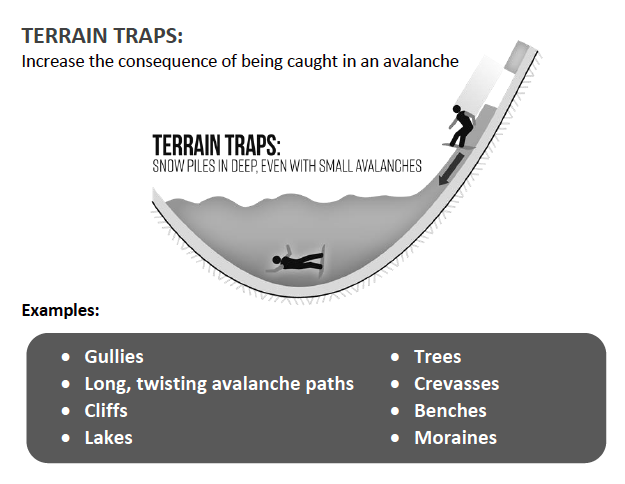
Other terrain features that are important to recognize are terrain traps. A terrain trap is any feature that increases the consequences of getting caught in an avalanche.
The basic understanding of avalanche terrain is a skill we hope to build in this lecture and in the field portion of your course. Let’s talk through essentials of terrain.
Now that you have a foundation for recognizing avalanche terrain, let’s talk about how you move through that terrain. What should you consider when you’re route finding going uphill, as well as when you are going downhill. We will discuss a few facets of backcountry travel techniques.
Start by reading the avalanche forecast: https://utahavalanchecenter.org/sites/default/files/archive/advisory/print/advisory/salt-lake/20161205.html
And check out these two observations: https://utahavalanchecenter.org/observation/28433 https://utahavalanchecenter.org/observation/28412
